The Middle East is building. Gas processing, LNG, petrochemicals, hydrogen and carbon capture projects are moving at a pace few other regions can match. At the same time, operators are extending the life of assets that have been producing for decades. Both create the same question. How do you know your fire and gas detection system will actually detect the hazard it was installed for? Micropack managing director Graham Duncan explains.
For a long time, the honest answer was that you didn’t. Detector layouts were typically produced by experienced engineers using judgement and rule-of-thumb spacing. Sometimes that judgement was good. Sometimes it wasn’t. Either way, there was no objective way to demonstrate coverage, and no way to show a regulator or an insurer that the design would perform.
From judgement to evidence
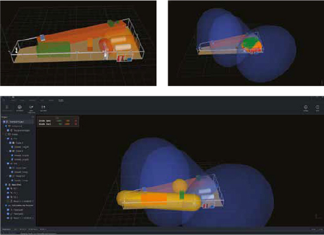
Fire and gas mapping changes that. It is a performance-based assessment of detector coverage, carried out in a 3D model of the facility. For flame detection, the assessment is geographic. Each detector’s field of view is modelled against the plant geometry, accounting for obstructions such as vessels, pipe racks and structural steel. The output is a coverage map showing exactly which areas can see a fire of a defined size, and which cannot.
For gas detection, the assessment is different. Gas clouds do not respect detector sightlines, so the analysis is volumetric or scenario-based, considering release points, ventilation and the size of cloud the system must detect before it becomes a threat.
The discipline now has a codified basis. BS 60080:2020 gives explicit guidance on the placement of flame and gas detectors, and ISA TR84.00.07 provides a framework for evaluating fire and gas system effectiveness. Together they move detector layout from an art to an engineering deliverable that can be verified, audited and handed over with the rest of the safety case.
Why it matters more in the Gulf
The Middle East presents specific challenges for optical flame detection. Intense sunlight, heat haze, dust and highly reflective surfaces all work against detection reliability. A detector that performs well in the North Sea will not necessarily behave the same way at a gas plant in the Empty Quarter in August. Radiant sources such as flare stacks and hot exhausts add further potential for false alarms.
This is where mapping earns its keep. The study does not just position detectors. It forces early decisions about detection technology, fire size targets and alarm voting philosophy, all assessed against the real environment rather than a datasheet. A mapping study that assumes ideal conditions is not worth the paper it is printed on.
There is an economic argument too, and it cuts both ways. Under-detection leaves hazards uncovered. Over-detection is the more common finding in practice. It is not unusual for a mapping study of an existing facility to show that coverage targets can be met with fewer, better-placed detectors than the original design assumed. Every detector removed saves capital cost, installation, cabling and a lifetime of maintenance and proof testing. On a large facility that adds up quickly.
Brownfield and newbuild
The regional opportunity splits into two workstreams. On new projects, mapping is increasingly written into the contract as a design deliverable, with coverage targets defined at FEED and verified before handover. Operators in the UAE and wider Gulf are adopting performance-based requirements in their own engineering standards, and EPC contractors are expected to demonstrate compliance rather than assert it.
On existing assets, the driver is assurance. Many facilities in the region are running detection systems designed twenty or thirty years ago, before mapping existed as a discipline. A retrospective study answers a simple question for the asset owner: does the installed system meet a modern coverage standard? Where it does, that is now demonstrable. Where it does not, the gaps are identified and can be closed in a planned way rather than discovered after an incident.
Building capacity in the region
The final piece is people. Fire and gas mapping is not software alone. The tools produce the coverage analysis, but the judgement about fire size, hazard grading and voting philosophy still sits with the engineer. As the Middle East localises more of its engineering capability, there is growing demand for structured training in fire and gas detection design, and for competency that can be assessed rather than assumed.
That is the future being mapped out in the region. Detection designed against defined performance targets, verified in a model before a single detector is installed, and maintained as a living record through the life of the asset. It is a straightforward idea. Safety systems should be proven to work, not assumed to. The Middle East’s new generation of projects is well placed to build that in from day one.
For more information visit: www.micropacksafety.com